Uyghur Language
Studies
Together we live this language.
'Geography has made us neighbors. History has made us friends. Economics has made us partners, and necessity has made us allies. Those whom God has so joined together, let no man put asunder.
_______John F. Kennedy
We have 1.6 million sq. km of geography in Uyghur Region_____Memet Tursun Zunun
Geography
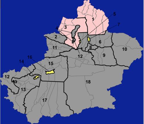
Cities, Perfectures, Stateand Counties in Uyghur Region
Map |
Names and Info |
English | Uyghur |
Uyghur Latin |
1 |
Altay |
Altay City |
ئالتاي شەھىرى
|
Altay Shehiri |
2 |
Bortala |
Börtala City |
بۆرتالا شەھىرى
|
Börtala Shehiri |
3 |
Tarbaghatay |
Chöchek City |
چۆچەك شەھىرى |
Chöchek Shehiri |
4 |
Karamay |
Karamay District Maytagh District Jerenbulaq District Orqu District |
قاراماي رايونى |
Qaramay Rayoni |
5 |
Shihenze (Administered by Xinjiang Production and Construction Corps) Shihenze Uyghur: شىخەنزە, Shihenze, Xihənzə) is a sub-prefecture-level city in northern Uyghur Region |
Shihezi City | شىخەنزە شەھرى |
Shixenze Shehri |
6 |
Sanji |
Sanji City Fukang City Michuen City Qutubi County Manas County Guchuni County Jimsar County Mori Kazakh Autonomous County |
سانجى شەھىرى |
Sanji Shehiri |
7 |
Wujiaqu (Administered by Xinjiang Production and Construction Corps) Wujiaqu (Chinese: 五家渠; pinyin: Wǔjiāqú, Uyghur: ۋۇجياچۈ, Wujyachü, Vujyaqü) is a sub-prefecture-level city in the northern part of Uyghur Region, north of Urumqi. |
Wujiachu City | ئۇجاچۇ شەھرى |
Wujachu Shehri |
8 |
Ürümchi Ürümqi or Ürümchi (English pronunciation: /uːˈruːmtʃi/; Uyghur: ئۈرۈمچی, Ürümchi; is the capital of the Uyghur Region |
Tengritagh District |
تەڭرىتاغ رايونى سايباغ رايونى يېڭى شەھەر رايونى شۇيموگۇ رايونى دۇڭسەن رايونى |
Tengritagh Rayoni DabanchengRayoni |
9 |
Turpan |
Turpan City Pichan County Toksun County |
تۇرپان شەھىرى |
Turpan Shehiri |
10 |
Qumul |
Qumul City Araturk County Barkol Kazakh Autonomous County |
قۇمۇل شەھىرى |
Qumul Shehiri |
11 |
Ili Ili Kazakh Autonomous Prefecture Kazakh: ىله قازاق اۆتونومىيالى وبلىسى, Іле Қазақ аутономиялық облысы, İle Qazaq awtonomïyalıq oblısı, Uyghur: ئىلى قازاق ئاپتونوم ۋىلايىتى, Ili Qazaq aptonom wilayiti, Ili Ķazaķ aptonom vilayiti), in northernmost Uyghur Region, is the only Kazakh autonomous prefecture of the Uyghur Region |
Tarbaghatay Prefecture |
تارباغاتاي ۋىلايىتى ئالتاي ۋىلايىتى غۇلجا شەھىرى |
Tarbaghatay Wilayiti |
12 |
Kizilsu |
Artush City Akto County Akchi County Ulugqat County |
ئاتۇش شەھىرى |
Atush Shehiri |
13 |
Kashgar Kashgar Prefecture Uyghur: قەشقەر ۋىلايىتى, Qeshqer Wilayiti, K̡əxk̡ər Vilayiti; also spelled Kashgar) is located in mid-western Uyghur Region, It has an area of 139,077 km². The capital of the prefecture is the city of Kashgar. |
Kashgar City Toqquzaq County Yengisher County Yengisar County Poskam County Yarkand County Kargilik County Makit County Yopurga County Peyziwat County Maralbeshi County Tashkorgan Tajik Autonomous County |
قەشقەر شەھىرى |
Qeshqer Shehiri |
14 |
Tumshuk (Administered by Xinjiang Production and Construction Corps) Tumshuk ; Uyghur: تۇمشۇق, Tumushuq, Tumxuk̡; also known as Tumushuk, Tumshuq, etc.) is a sub-prefecture-level city in the northern part of Uyghur Region, it is located in western Uyghur Region, surrounded by Kashgar Prefecture. |
Tumshuk City | تۇمشۇق شەھرى |
Tumshuq Shehri |
15 |
Aksu Aksu Prefecture Uyghur: ئاقسۇ ۋىلايىتى, Aqsu Wilayati, Ak̡su Vilayiti) is located in mid-western Uyghur Region, It has an area of 132,500 km². The name Aksu is Uyghur for 'white water'. |
Aksu City Onsu County Kuchar County Shayar County Toksu County Bay County Uchturpan County Awat County Kalpin County |
ئاقسۇ شەھىرى |
Aqsu Shehiri |
16 |
Aral (Administered by Xinjiang Production and Construction Corps) Aral ; Uyghur: ئارال, Aral, Aral is a sub-prefecture-level city in Uyghur Region, Often misspelled as "Alar". |
Aral City | ئارال شەھرى |
Aral Shehri |
17 |
Hotan The Hotan Prefecture, Uyghur: خوتەن ۋىلايىتى, Xoten Wilayiti, Hotən Vilayiti)[1] is located in the south-western part of theUyghur Region. It is sometimes (unofficially) spelled as Khotan. |
Khotan City Khotan County Karakash County Guma County Lop County Chira County Keriye County Niye County |
خوتەن شەھىرى |
Hoten Shehiri |
| 18 | Bayingolin |
Korla City |
كورلا شەھىرى بۈگۈر ناھىيىسى لوپنۇر ناھىيىسى چاقىلىق ناھىيىسى چەرچەن ناھىيىسى خېجىڭ ناھىيىسى خوشۇت ناھىيىسى باغراش ناھىيىسى يەنجى خۇيزۇ ئاپتونوم ناھىيىسى |
Korla Shehiri Bügür Nahiyisi Lopnur Nahiyisi Chaqiliq Nahiyisi Cherchen Nahiyisi Xéjing Nahiyisi Xoshut Nahiyisi Baghrash Nahiyisi Yenji Xuyzu Aptonom Nahiyisi |
Xinjiang Production and Construction Corps in Uyghur Region
The Xinjiang Production and Construction Corps ( Uyghur:ئشىلەپچىقىرىش قۇرۇلۇش بىڭتۇەن simplified Chinese: 新疆生产建设兵,; traditional Chinese: 新疆生產建設兵團; pinyin: Xīnjiāng Shēngchǎn Jiànshè Bīngtuán), also known as XPCC or Bingtuan or Bing Tuan for short, is a unique economic and semi-military governmental organization existing in Uyghur Region. The XPCC has de facto administrative authority over several medium-sized cities as well as settlements and farms all across Uyghur Region. It has its own administrative structure, fulfilling governmental functions such as healthcare and education for areas under its jurisdiction. The Government of Uyghur Region does not usually interfere in the administration of these areas.
The stated goals of the XPCC are to develop frontier regions, promote economic development, ensure social stability and ethnic harmony, and counter the East Turkestan independence movement. In its 50-year history, the XPCC has built farms, towns, and cities,resevoirs and settled millions of migrants, mainly Han Chinese, into Uyghur Region. As such, the XPCC is lauded in China as a cornerstone of stability and prosperity in an otherwise troubled region, and characterized as a vehicle of colonization and sinicization among supporters of East Turkistan independence.
The XPCC also participates in economic activities, and is known as the China Xinjian Group (simplified Chinese: 中国新建集,; traditional Chinese: 中國新建集團; pinyin: Zhōngguó Xīnjiàn Jítuán). It has a number of publicly traded subsidiaries.
The XPCC was founded by Wang Zhen in 1954 under the orders of Mao Zedong.
Organization
The XPCC is administered by both the central government of the People's Republic of China as well as the government ofUyghur Region. It has sub-provincial powers on par with sub-provincial cities, and its economic and social development are administered separately from that of Uyghur Region. The area and population of the XPCC are generally given as part of Xinjiang's total figures, but the GDP of the XPCC is generally listed separately.
The XPCC is subdivided into divisions, then regiments. It is headquartered at Urumqi. Each XPCC division corresponds to a prefecture-level administrative division of Uyghur Region, and are in themselves sub-prefectural in rank.
The XPCC itself, as well as each individual division, is headed by three leaders: a first political commissar, a political commissar, and a commander. The role of first political commissar of the XPCC is filled by the CPC Xinjiang committee secretary, and the first political commissars of each XPCC division is likewise the committee secretary in each of the corresponding prefecture-level divisions.
In addition to regiments, the XPCC also administers regiment-level farms and ranches.
At the end of the 20th century, the military role of the XPCC has been diluted, being given instead to the Xinjiang Military District, a part of the Lanzhou Military Region that includes all of northwestern China. At present, the military personnel of the XPCC are mostly reservists or militia.
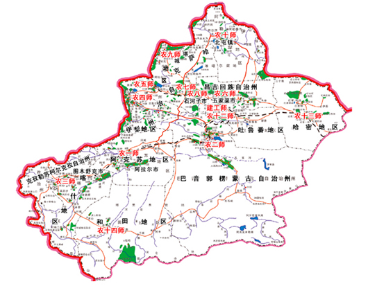
Details of Xinjiang Production and Construction Corps in Uyghur Region
| Divisions Name | In Uyghur | In Uyghur (Latin) | Found | regiment-level entities (including regiments, farms, and ranches | in Uyghur DM= déhqanchiliq meydani |
Location (Approx) | HQs, Cities |
|
|---|---|---|---|---|---|---|---|---|
1st Division |
يېزا ئگىلىك 1-دىۋىزىيە | Yéza Igilik 1-déwiziye | 1953 | Aral City and 16 Regiments (1-16) | 1~16 tuen | Aksu Prefecture | Aksu/Aral | |
| 2nd Division 农二师 |
يېزا ئگىلىك 2-دىۋىزىيە | Yéza Igilik 2-déwiziye | 1953 | 21, 22, 24, 25,
27, 29,30,31, 33, 34, 36, 223, |
21-36-tuen, 223-tuen | Bayin'gholin Mongol Autonomous Prefecture | Korla | |
| 3rd Division 农三师 |
يېزا ئگىلىك 3-دىۋىزىي | Yéza Igilik 3-déwiziye | 1966 | 41,45,53,
44, 46, Farms: Peyziwat, East wind , Red Flag, Yarkent, Kargilik, Toyun |
41~53-tuen, peyziwat merkizi DM,sherqi shamili DM, qizil bayraq DM,yeken DM, qaghiliq DM, toyun DM | Kashgar Prefecture | Kashgar Tumshuk | |
| 4th Division 农四师 |
يېزا ئگىلىك 4-دىۋىزىي | Yéza Igilik 4-déwiziye | 1953 | 61, 62,63, 64,
65, 66,67, 68,
69, 70,71,72,
73, 74, 75,76,
77, 78, 79, Farms: Beshdong , liyangfen |
61~79-tuen, beshdöng DM , liyangfen DM |
Ili Kazakh Autonomous Prefecture (southern, directly administered portion) |
Ghulja | |
| 5th Division 农五师 |
يېزا ئگىلىك 5-دىۋىزىي | Yéza Igilik 5-déwiziye | 1953 | 81, 83, 84,86, 87, 88, 89,90, 91, | 81~91-tuen | Bortala Mongol Autonomous Prefecture | Bortala | |
| 6th l Division 农六师 |
يېزا ئگىلىك 6-دىۋىزىي | Yéza Igilik 6-déwiziye | 1953 | 101, 102,103, 105, 106, Farms: fang sawxu ,shinxu , jünxu, Youth Union,liyu yunxu, tudunzi,Red Flag, guchung |
101~111-tuen’, fang sawxu DM,shinxu DM,jünxu DM, yashlar ittpaqi DM, liyu yunxu DM, tudunzi DM,qizil bayraq DM, guchung DM, beytik DM. | Changji Hui Autonomous Prefecture | Wujiaqu | |
| 7th Division 农七师 n |
يېزا ئگىلىك 7-دىۋىزىي | Yéza Igilik 7-déwiziye | 1953 | 123, 124, 125, 126, 128, 129, 130, 131, 137, | 123~137-tuen | area west of Karamay | Kuitun/ Tianbei New District of Kuitun | |
| 8th Division 农八师 |
يېزا ئگىلىك 8-دىۋىزىي | Yéza Igilik 8-déwiziye | 1953 | 121, 133, 134,
136, 141, 142,
143, 144, 147,
148, 149, 150,
152, Shixenze Head Farm |
121-122-tuen,132~136-tuen, 141~144-tuen, 147~152-tuen shixenze bash meydani | area east of Karamay | Shihezi | |
| 9th Division 农九师 |
يېزا ئگىلىك 8-دىۋىزىي | Yéza Igilik 9-déwiziye | 1962 | 161, 162, 163,
164, 165, 166,
167, 168, 169,
170, Chinggil Farm |
161~170-tuen, ittipaq DM | Qoqek Prefecture of Ili Kazakh Autonomous Prefecture | Dorbiljin County | |
| 10th Division 农十师 |
يېزا ئگىلىك 10-دىۋىزىي | Yéza Igilik 10-déwiziye | 1959 | 181, 182, 183, 184, 185, 186, 187, 188, | 181~190-tuen,chinggil DM |
Altay Prefecture of Ili Kazakh Autonomous Prefecture | Beitu, town of Beitun |
|
| Engi- neering Division |
قۇرۇلۇش دىۋىزىيەسى | Qurulush diwiziyesi | 1953 | Engineering 1-8 | qurulush 1~8-tuenliri | N/A | Urumchi | |
| 12th Division 农十二师 |
يېزا ئگىلىك 12-دىۋىزىي | Yéza Igilik 12-déwiziye | 1982 | 221, Farms: Senping , 1st May , Tudunxaba , West Mount , Bird Farm, |
104-tuen, senping DM,,1-may DM, tudunxaba DM, gherbi tagh DM, qush férmisi, 221-tuen |
Urumqi prefecture-level city | Urumchi | |
| 13th Division 农十三师 |
يېزا ئگىلىك 13-دىۋىزىي | Yéza Igilik 13-déwiziye | 1982 | Farms: 1st, 2nd, 3nd redstar, Saqa ,Rocket, lyushuchuen 1st, 2nd, redstar Animal , Redhill, Nom | qizil yultuz1-2-3-4-déhanchiliq meydanliri, saqa DM, rakéta DM, lyushuchuen DM, qizil yultuz1-2-charwichiliq meydani, qiziltagh DM, nom DM |
Kumul Prefecture | Kumul | |
| 14th Division 农十四师 |
يېزا ئگىلىك 14-دىۋىزىي | Yéza Igilik 14-déwiziye | 1982 | 47, Farm: 1st Animal Farm and Guma |
47-tuen, 1-charwichiliq meydani, guma DM | Hotan Prefecture | Hotan |
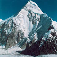 |
Khan Tengri (“Lord of the Sky”) in the Tengri Mountains Range (23, 620 ft.). (The Tengri Mountains and Pamir mountain ranges are the most important in Central Asia . They provide much of the region’s renewable water supply because (1) they are the sources of major rivers, and (2) the runoff from melting mountain snow provides water to feed underground springs. These springs enable farmers in desert oases (see Document 2) to grow grain, fruits, and vegetables. Also, water stored up in glaciers and frozen mountain soil provides a reserve supply in years of drought. |
|---|---|
 |
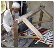
The silk trade that gives the Silk Roads its name began as early as the second century BCE when caravans carried Chinese silk across Central Asia. Some silk eventually reached the Mediterranean, where wealthy people in ancient Rome wore it. Silk was also often used as money. Silk comes from the cocoons of silkworms (photo, left). Silk production depends on knowing how to raise silkworms on a diet of mulberry leaves, as well as how to reel the thread from the cocoons, dye the raw material, and eventually turn it into clothing. |
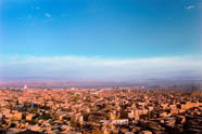  |
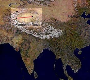
Kashgar was a major oasis stop for exhausted travelers going both east and west. If you were going west around the northern or southern edges of the Taklamakan Desert, Kashgar was at the location where these two routes merged. It was also the closest oasis after descending from the Pamir Mountains to its west or the Tianshan range to its north. Chinese merchants would arrive in Kashgar and trade their goods before returning home. A few would make the journey west over the Pamirs or tengri Mountains, going farther into Central Asia. Eastbound travelers would descend from the mountains and exchange their yaks for camels to journey across the Taklamakan Desert.
Kashgar was strategically and economically important and many battles were fought to control it. |
 |
Turpan, one of the key oases along the northern route of the ancient Silk Road, is situated south of the Tianshan Mountains in the eastern part of today’s Xinjiang Province. Turfan is the lowest point in China and has the country’s highest temperature. Turfan is famous for its grapes, raisins, and wine. The cultivation of grapes is made possible by the karez system, underground channels that bring water down from the melting snow in distant mountain ranges. The karez are vital to the economic development of the region. |
|
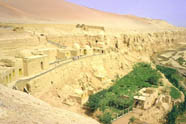
Kotan, an oasis south of the Taklamakan Desert, has been known for centuries as a source of jade. Much of the jade went to China where it was carved by highly skilled artisans into trinkets for the imperial family and the aristocracy. Jade is an extremely hard material, and to shape it takes hours of grinding with find sand, water and drills made with diamond points. Intricately carved pieces, such as hair ornaments and belt buckles, were therefore particularly prized (Whitfield 1999: 127). |
FEATURED INFO
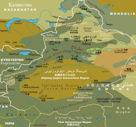
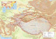
The Uyghur Region
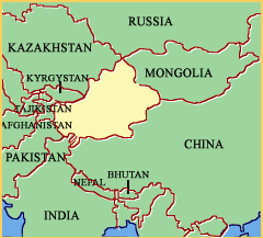
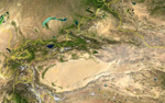
Uyghur Region spans over 1.6 million sq. km and borders Russia, Mongolia, Kazakhstan, Kyrgyzstan, Tajikistan, Afghanistan, Pakistan and India, has abundant oil reserves and is China's largest natural gas-producing region. It administers most of Aksai Chin, a territory formally part of Kashmir's Ladakh region over which India claims sovereignty since 1962.
"Xinjiang" literally means "New Frontier", a name given during the Qing Dynastyin 1884. It is home to groups include Uyghur, and some Kazakh, Hui, Kyrgyz and Mongol. Older English-language reference works often refer to the area as Chinese Turkestan. Sinkiang and East Turkestan. Uyghur Region is divided into the Dzungarian Basin in the north and the Tarim Basin in the south by a mountain range.
With a documented history of at least 2,500 years, and a succession of different peoples and empires vying for control over the territory, Uyghur region has been, and continues to be, a focal point of ethnic tensions well into the beginning of the 21st century.
Geography and Geology
 Uyghur Region is split by the Tengritagh mountain range (Uyghur: تەڭرى تاغ, Tengri Tagh), which divides it into two large basins: the Dzungarian Basin in the north, and the Tarim Basin in the south. Much of the Tarim Basin is dominated by the Taklimakan Desert. The Second lowest point in in the world, is the Turpan Depression, 155 metres below sea level; its highest point is the mountain K2, Austin Godwin, known as Chogri to Uyghur, 8611 metres above sea level, on the border with Pakistan. Other mountain ranges include the Pamir Mountains in the southeast, the Karakoram in the south, and the Altai Mountains in the north.
Most of Uyghur Region is young geologically, having been formed from the collision of the Indian plate with the Eurasian plate, forming the Tengri Mountain , Qarakorum Mountans, and Pamir mountain ranges. Consequently, Uyghur Region is a major earthquake zone. Older geological formations occur principally in the far north where the Junggar Block is geologically part of Kazakhstan, and in the east which is part of the North China Craton.
 Uyghur Region has within its borders the point of land remotest from the sea, the so-called Eurasian pole of inaccessibility (46°16.8′N 86°40.2′E / 46.28°N 86.67°E / 46.28; 86.67 (Eurasian pole of inaccessibility)) in the Dzoosotoyn Elisen Desert, 1,645 miles (2648 km) from the nearest coastline (straight-line distance).
The Tengri mountain range marks the Uyghur Region -Kyrgyzstan border at the Torugart Pass (3752 m). The Karakorum highway (KKH) links Islamabad, Pakistan with Kashgar over the Khunjerab Pass.
The Geographical-Historical Perspective
The terrain of Uyghur Region can be summarized as "Three Mountain Ranges Embracing Two Basins". The main basin is of course the Tarim Basin, which covers about half of the area of Uyghur Region, from the city of Kashgar in the west to Lop Nur (Lake Lop) in the east, and from the Qarakorum Mountains in the south to the Tengri Mountains in the north. Uyghur Region 's second basin is the Junggar Basin, which lies between the Tengri Mountains to the south and the Altay Mountains to the north, meaning that the Junggar Basin lies north of the Tarim Basin. While the Tarim Basin spans an area of some 530,000 square kilometers, the Junggar Basin spans less than half of that, or about 200,000 square kilometers.
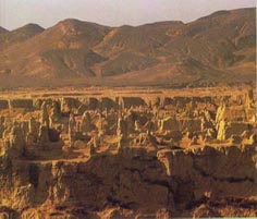
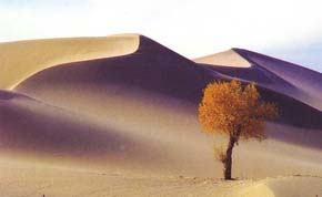 In the central part of the Tarim Basin lies one ofe the world's largest moving desert, the Takla Makan Desert, covering an area of 330,000 square kilometers, making it larger than the Junggar Basin itself. The Takla Makan Desert is the second-largest moving desert in the world, the largest such desert being the Sahara. The Takla Makan is moving northward. A look at a map of Uyghur Region shows that the eastern arm of the tengri Mountain Range is at a significantly lower altitude than the western arm of the mountain range. In fact, the center of the eastern arm of the Tengri Mountain Range encompasses a huge depression, or deep mini-basin, the Turfan Depression, in which sits the relatively large city of Turpan. In time, the Takla Makan Desert will surely engulf the entire eastern arm of the Tengri Mountain Range, eating up the Turfan Depression and linking up with the Junggar Basin. When that happens the above defining expression for Uyghur Region will have to be changed to "One Huge Basin Embracing Three Mountain Ranges
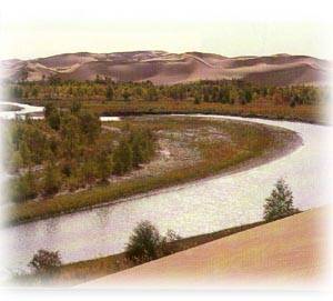 Uyghur Region 's longest river - the Tarim River, was at about 2100 kilometers –now it was reduced to about 1400 km, the report in Uyghur Region Periodical clearly indicated that the water at the 1200km is undrinkable, due the decrease of the water resource and too many reservoir were setup at the upper stream. was also World's longest inland river (i.e., not emptying directly into the ocean). The Tarim River's two westernmost branches are the Zerepshan and the Aksu Rivers, the latter of which originates in the tengri Mountains of Kyrgystan and flows southeast where it links up with the Zerepshan River, which originates in the Qarakorum Mountains of southwestern Uyghur Region, then flows northeast. The Zerepshanitself is fed by the Kashgar River, which also originates in the Qarakorum Mountains, slightly west of the point of origin of the Zerepshan River.
The Tarim River is also fed by the Hotan River, also originating in Uyghur Region 's qarakorum Mountains. Additionally, the Tarim River is fed farther west along the northern rim of the Tarim Basin by the Kaydu-Konchi River system (the two rivers link up in the area around Lake Bostan, near the southern foothills of the eastern arm of Uyghur Region 's tengri Mountains), though, today, this only occurs with the help of man-made hydraulics (in the past, the Kaydu-Konqi River system did indeed connect directly to the Tarim River, but past floods have resulted in a change in the course of this river system.
Agriculture
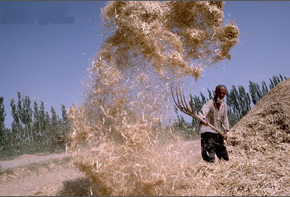 There are a couple of very good reasons why Uyghur Region relies heavily on agricultural production rather than industrial production. Firstly, the number of rivers in the Tarim Basin, together with the long growing season and the plentiful sunshine, makes agricultural production a natural choice, even though parts of the basin receive little water. The other reason is that the region's distance from the raw material sources as well as from the marketplaces for the end products means that industrial production in the region would not currently make economic sense, though this could change if export markets were to open up in neighboring countries.
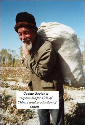
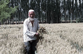 The main crops of Uyghur Region are: cotton, hops, safflower, medlar (an apple-like fruit native to Europe, South Africa, and Eurasia - including Uyghur Region - the European variant of which fruit bears the Latin name Mespilus germanica), tomato, cantaloupe, grape wine, fragrant pears, and megranate (the large edible fruit of the peony megranate tree (Punica granatum), apparently related to the pomegranate; the peel of the megranate fruit is also used as a natural dye).
Some figures:
Uyghur Region is responsible for 40% of China's total production of cotton,50% of its medlar, 60% its safflower and 70% of its hops.
Some More
Uyghur Region also has twenty-three nature reserves, they are the habitat of a number of rare plants as well as threatened animal species.
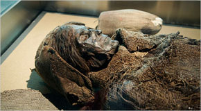
Uyghur Region boasts several historical and cultural sites, including religious sites. These include: Idiqut Ruins, Astana Ruins, Kizil Thousand Buddha Grottoes, and Kroran Ancient City, near Lake Lop (Lop Nur) on the eastern rim of the Tarim Basin, a Silk Road city whose mysterious and catastrophic fate matches that of the Ancient City of Niya, which also lies in Uyghur Region, near the southern rim of the Tarim Basin (see footnote 2 below).
Kroran is also the site of the finds of a number of Tocharian mummies, including the so-called "Beauty of Kroran", a 4000-year-old mummy found in such excellent condition that artists have recreated her presumed physiognomy (in fact, her entire head, replete with long flowing hair), based on her bone structure.
Karez Keeper-The Karez System and Uyghur Region’s Oasis Town
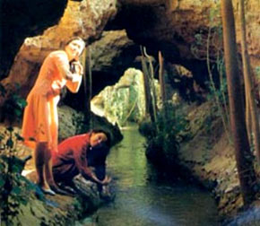
The oasis towns that flourish in the arid region along the Silk Roads depend on an ancient system of water distribution known as the karez. The word karez is from the Uyghur language: Kar means “well” and ez means “underground.” Depending on gravity, the karez consist of underground channels that bring water down from the melting snow in distant mountain ranges.
Since the water flows underground, it doesn’t evaporate in the fierce heat of this desert region. Karez played an important role in the development of the Turpan Basin, particularly near the oasis towns of Qu,uland Turpan. The chief tools for digging the karez are simple: the hammer and the pickaxe. The main parts of the karez are (1) the subsurface tunnels that collect and transport water; (2) the openings at ground level that allow workers to maintain the channels—the most important job being to make sure the water flow isn’t interrupted by the accumulation of fine particles of earth, called silt, suspended in the water; (3) the ponds that collect the water just before it is channeled into the fields.
Since more than ninety percent of the land in the western regions requires irrigation, without the karez, agriculture would be impossible. Karez are used to water wheat, corn, sorghum (a grain resistant to drought and heat), rice, melons, grapes, and sugar beets. Long-staple cotton, which thrives in an arid climate, is also grown in the Tarim Basin.
This traditional system has existed in harmony with the environment for centuries. The earliest Chinese account of the karez dates to about 100 BCE.
The Karez Irrigation System
Karez are underground channels that bring water from highlands to lower levels solely through gravity. Karez require no pumps or other mechanical means to operate. They depend entirely upon the supply of groundwater. 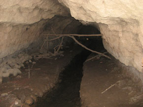 Building a Karez
The shaft at the far right is labeled “head well.” The horizontal tunnel at the bottom of the drawing is being dug toward it. The vertical shafts are sunk every sixty to ninety feet.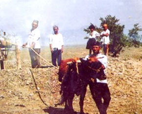 A Karez Seen from “From the air, the tunnel portion of a karez system looks like a line of anthills leading from the foothills across the desert to the greenery of an irrigated settlement”
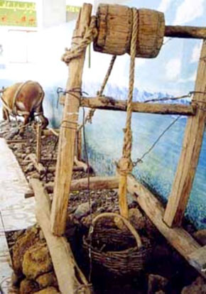 The bucket is used to clean out the channel. This is the most important job in keeping the karez in working order. Geography Along The Silk Roads
THE CLIMATE OF CENTRAL ASIA Inner Asia includes the following regions and countries:
1. CENTRAL ASIA:
1.Uyghur Region,
2.Uzbekistan,
3.Kazakhstan,
4. Kyrgyzstan,
5.Tajikistan,
6.Turkmenistan,
7. Northern Afghanistan
2. SOUTHERN SIBERIA
3. INNER MONGOLIA
4. MONGOLIA
5. TIBET
Inner Asia and Central Asia are far away from oceans and are therefore very dry. This is because winds from the ocean lose their moisture by the time they reach the region. Holding little humidity, winds in this region produce only limited condensation even as they are cooled. Average annual rainfall throughout the region cannot support farming.
Central Asia has some of the greatest climatic extremes in the world. Owing to its vast size and the distance of the interior from the moderating influences of the ocean, there is a tremendous difference in temperatures between summer and winter.
The dryness of the air over the desert permits a large proportion of the sun’s heat to penetrate to the surface, so that during the brief summer the bare earth becomes very hot. Rock surfaces exposed to the sun may have a temperature of 150º F or above during the middle of the day while the air itself may be 100º F. During the winter the transparent nature of the atmosphere permits radiation to cool the earth excessively so that the weather becomes bitterly cold, with temperatures down to -40º F. Descending air currents also bring cold air from the upper atmosphere.
This region has two seasons rather than four. Winter may be said to last for eight months and is abruptly followed by a short, hot summer. Frosts occur early in September and the few streams are frozen by October (Adapted from Cressey 1934: 252).